Sunday 16 October 2016

We participated the river restoration conference in Cracow

Tomáš Galia, Jan Hradecký and Václav Škarpich participated the conference 'Towards the Best Practice of River Restoration and Maintenance', which took place 20-23/9 in Cracow (PL) under organisation of Ab Ovo Association, Institute of Water Engineering and Water Management, Krakow University of Technology, University of Agriculture in Krakow, Institute of Nature Conservation, Polish Academy of Sciences in Krakow, Institute of Geography, Pedagogical University of Krakow and Regional Water Management Board in Krakow. Tomáš Galia spoked about effects of check-dams on channel morphologies and bed sediment parameters and he also presented some possibilities to restore such type of managed streams. Václav Škarpich discussed the role of human impact connected with the increase in stream power in managed gravel-bed rivers. Many interesting topics were presented through the conference, which dealt with natural function of rivers, ecosystem services and river restorations (see the book of abstracts free available for download).  

The 3-day field trip took place immediately after the conference in a smaller group of scientists. Colleagues from Poland showed us their study locations (e.g. Czarny Dunajec, Kamienica, Biala, Bialka), where we could see incision tendencies of Carpathian gravel-bed rivers as same as 'close-to-natural' reaches with wandering river patterns and development of islands or a mountain stream with log-jams. Also the approaches of local river restorations or a flood hazard by instream wood transport were illustratively demonstrated in the field. This trip was held in a very friendly atmosphere, giving us a great opportunity to discuss (not only) the issues of gravel-bed streams with well-known colleagues from abroad. We would like to thank especially to Bartek Wyzga and Joanna Zawiejska for the preparation and organisation of this field trip and conference.      
Restored check-dam with a fish-passage (the Krzczonówka Stream). 

Newly constructed erodible corridor in the Raba River

Demonstration of instream wood flood hazard in the Czarny Dunajec

Incision in the Bialka River (Polish-Slovakian border)

Deposited instream wood after a flood in the Czarny Dunajec upstream the Czorstyn Reservoir

Logjam in the Kamienica Stream (Gorce Mts.)

Erodible corridor in the Biala River

Monday 3 October 2016

The effects of river patterns on riparian vegetation: A comparison of anabranching and single-thread incised channels

On September 2016, study about channel changes of the Morávka River and their effect on riparian vegetation was published.
Riparian vegetation reflects the current conditions and the dynamics of streams. The floodplain vegetation along the watercourse of the Morávka River was subject to study in this project. In some reaches, the river has the natural character of an anabranching gravel-bed stream; in contrast, other Morávka R. reaches are incised into the bedrock. These cases were used to assess potential changes in vegetation conditions as evidence of negative processes taking place in the gravel-bed streams of the Beskydy Mts. The results demonstrate a higher biodiversity in the floodplain along the anabranching river channel. In contrast, the floodplain along the incised river channel shows low biodiversity values. Redundancy analysis was used to determine the relationships between plant species composition, distance from the main channel and relative elevation from the mean water level of the main channel. In addition, the results show a higher degree of change in plant species composition on the floodplain along the incised river channel. The analysis of floodplain groundwater fluctuations shows a decreasing trend in the annual maximum groundwater level.
The paper has been recently published in Moravian Geographical Reports journal.


The Morávka R.: A – single-thread bedrock-incised channel river; B – anabranching channel river reach
Photo: V. Škarpich.
 
A – Shannon-Wiener index and B – Simpson's index of phytosociological relevés in the study area of the Morávka River floodplain. Source: authors’ elaboration.

Thursday 29 September 2016

Geomorphic impact of historical slate mining activity on gravel-bed streams

Our present research concerned on the geomorphic effect of historical mining of slate slabs on small stream channels. The mining activity in the Nízký Jeseník Mts (Eastern Sudetes) took place mainly in 19th century and almost all mines and quarries were closed until 1950s. Unusable rocks were usually deposited on dumps in front of the mine entrances and quarries. Dumps located on the hillslopes adjacent to the channels and former floodplains were studied as important inputs of coarse material for local streams and the alterations in bed grain-sizes and channel morphologies were evaluated.  The sediment supply from investigated dumps in low-order (I-III.) channels often transformed channel-reach morphologies (pool-riffles to plane beds), significantly altered adjacent and downstream caliber of bed sediments, and decreased the bankfull width near the points of active sediment inputs. This supply of larger grains into channels also increased potential stability of channel beds. By increased transport capacity of a stream, the significance of slate dumps as sediment inputs for evaluated supply limited or transport-balanced streams decreased as expressed obtained results for larger IV-order gravel-bed stream.
The paper has been recently published in Zeitschrift für Geomorphologie

Large slate dump in Deštná
Slate dump coupled with the channel - the case of the Lobník Stream.

Increased bed grain-sizes near the positions of active sediment inputs. Supplied slate slabs
significantly exceed  stream transport capacity calculated for bankfull flows.

Sunday 4 September 2016

Inventory of large wood in the Odra River

The upper Odra River upstream Ostrava City represents unique geomorphic meandering pattern on the boundary between the Western Carpathians and Bohemian Massif. During the first week of September, the inventory of instream wood in the protected area of the Odra River took place, where the removal of large wood due to flood risk is prohibited since 2015. In total, 146 individual pieces of large wood were measured and positions of additional large wood jams (several including up to 20 logs) were mapped in ca. 4 km long reach. In addition, 32 large wood pieces were tagged in order to observe their future movement during high water stages. We assume extensive lateral supply of instream wood particularly in active meanders, which was also documented during field mapping.   


Wednesday 10 August 2016

Field measurements with Polish colleagues in the Morávka River

The research of the Morávka Canyon continued during the first week of August, when colleagues from the Cracow Agricultural University, namely Prof. Radecki-Pawlik and Dr. Plesinski visited this locality. We focused on detailed hydraulic measurements and geodetic survey of channel-reaches containing large artificial boulders (mainly from destroyed rip-rap structures). This could help us to answer the question, whether these boulders prevent from further erosion or potentially accelerate erosion processes via concentration of water flows. Additional measurements of present bed sediments and old gravels hanging on canyon walls provided information about changes in the river transport capacity. 
Detailed hydraulic measurements and geodetic survey of water surface and river bed

Pre-incision gravels of the Morávka Canyon

Thursday 23 June 2016

Workshop “Methods of detailed analysis in fluvial geomorphology” was realized


21st – 22nd of June, 2016

Lecturers:
Dr. Václav Škarpich (member of Czech-Rivers group of the fluvial section of the Department of Physical Geography and Geoecology, University of Ostrava)
Dr. Jan Blöthe (University of Bonn)
Dr. Veronika Kapustová (University of Ostrava)

Many aspects of fluvial processes and morphology may be measured to help to assess conditions of rivers. Modern research methods in fluvial geomorphology provide an integrated approach to the guidance for researchers to answer questions on river behaviour. The workshop “Methods of detailed analysis in fluvial geomorphology” was addressed to those students and young researchers who are dealing with river systems and hydrology. General aim of the workshop was a demonstration of modern methods and their application in fluvial-geomorphic research. The workshop was focused on practical presentation of basic methods for data collection in the field and subsequent analysis of obtained data, e.g., using BAGS (Bedload Assessment for Gravel-Bed Streams) software or Sedimetrics Digital Gravelometer. We showed how to obtain high-resolution remote sensing data using UAV technology and how to digitally reconstruct terrain and objects using Structure from Motion technique. One of the lecturers was Dr. Jan Blöthe from the University of Bonn, staying at our Department via Erasmus+ teaching mobility.

Photo of the Bečva R. channel obtained by UAV technology

Photo of the Bečva R. channel obtained by UAV technology

Dr. Jan Blöthe and students are operating UAV technology

Measuring of flow velocities by students

Tuesday 21 June 2016

River wood in Beskydian headwaters

The first results from the research of river wood in Mazácky Gruník natural monument (protected since 1950s) were presented at EGU conference in Vienna (April 2016) - see the poster below. Field works including dating of key logs in three headwater channels have been finished in the middle of June. Preliminary results show, that observed volumes of river wood are probably not at the 'natural' level before first human interventions (including forest management with removal of logs from channels) and some longer recovery time for development of log jams is needed. However, the research in this topic will continue in the month of July, when there is planned measurement and tagging of large wood in two meandering channel-reaches of the Odra River. 
Poster from EGU 2016 conference.

Saturday 18 June 2016

Short report from a field trip to Swiss torrents

Colleagues K. Šilhán and R. Tichavský from dendroman.cz and T. Galia participated the field trip to typical check-dam managed stream and the experimental watershed of the Erlenbach Stream, both located in the pre-alpine area of Switzerland. Flood events during past decades in the Gürbe Torrent (Bern canton) caused some serious damages in the forefield villages due to massive bedload transport and deposition of coarse material. A reconstruction of grade-control structures (mainly classic check-dams) took place in 2007-2009, when the first control structures were implemented in the middle of 19th century.

Check-dams in the Gürbe Torrent

Measurements of bedload transport in the Erlenbach Stream has been performed for 30 years. Flow discharge is measured and sediment is collected in a retention basin (capacity ca. 2000 m3). Sediment transport has been also continuously monitored with piezoelectric bedload impact and geophone sensors since 1986 and by an automatic system with special baskets to obtain bedload samples. In this watershed, other experiments as evaulation of water chemistry or slope-channel coupling processes take place. The rest of stay in Switzerland was dedicated to meeting with colleagues from dendrolab.ch also including discussions about river wood research in study sites in the Czech Republic (the Mazák Stream, the Odra River).
Bedload transport measurements in the Erlenbach Stream

Tuesday 31 May 2016

Outputs from the START project were presented

26th of May, 2016

Workshop entitled Quantification of morphological changes in river channels and its impact on flood risk was realized.
Rivers are dynamic systems, where changes in their morphology can affect all kinds of flooding and play a crucial role in a flood risk. The main historical changes were caused by increasing urbanization in the river landscape and direct human interventions. As results, the alteration in the shape of the channel, longitudinal profile, land use and placement of structures into the channel and floodplain took place. The interventions affected hydrological response of catchments, particularly in the forms of accelerated flow velocities, erosion, and interrupted periodical inundation.


Main objectives that have been presented were connected with the issues of quantification of morphological changes in river channels and their impact on a flood risk. The research was conducted in two Carpathian rivers situated in the Czech Republic and Slovakia (the Bečva River and the Topl'a River). This workshop summarized results from the research, when it was designed to help improve the integrated river basin management. Obtained results will help to find the strategy to mitigate the flood risk in studied areas.

Part-financed by the European Union.


Thursday 14 April 2016

Anthropogenic impact and morphology channel response of Beskydian gravel-bed rivers: a case study of the Ostravice River, Czechia


Beskydian streams have been recently subject to geomorphological transitions as a result of human interventions in local landscape and stream channels. The main aim of paper Anthropogenic impact and morphology channel response of Beskydian gravel-bed rivers: a case study of the Ostravice River, Czechia is to assess the morphological changes in the studied section of the Ostravice River. In particular, the study concerns four basic areas: (i) river pattern change, (ii) active channel change in the past 200 years, (iii) an analysis of channel incision, and (iv) a comparison of the Ostravice River transformation trends with selected European gravel-bed rivers. A large set of interventions into the fluvial regime of the Ostravice River were man-made projects, specifically the construction of weirs, valley dams and channel control works as bank stabilization affected the fluvial processes operating in the Ostravice River channel. Systematic regulation of the examined section started at the beginning of the 20th century. These interventions influenced the Ostravice River channel which underwent a rapid change in connection with active channel narrowing and incision. The active channel width was measured using the maps of the Second Military Mapping from 1836 to 1852 (on a scale of 1:28,800), the Third Military Mapping from 1876 to 1878 (on a scale of 1:25,000) and aerial images from 1937 to 2010.
This resulted in the original anabranching river pattern has been gradually replaced by a single, narrowed channel. The reach in r. km 0.0–9.0 displays a trend of channel narrowing between 1966 and the present. The previous period was characterised by a stagnation of the channel width. From the point of view of active channel development, a Mann-Whitney U-test at the significance level of α = 0.05 was used to assess the development of the change. The test shows values of no significant difference from the first half of the 19th century until 1966. From 1966 to the present, the Mann-Whitney U-test confirmed a significant difference in the channel width in this area. At some sections, the original riverbed was lowered by as much as 2.5 m in the second half of the 20th century. At other sections, the original riverbed was lowered by as much as 2.3 m in the first half of the 20th century and 2.0 m in its second half. The river reach 9.0–25.0 km displayed a significant change during the period of 1836–1852 to 1955. Between 1955 and 1966, there was no observed, significant change in the channel width. Between 1966 and the present, there has been a notable progressive channel narrowing. The studied reach of the 25.0–38.0 km displayed a significant change in the channel width between 1836–1852 and 1876–1878 and between 1937 and the present. But the first period from the 1836–1852 is characterised by lower values of the Mann-Whitney U-test. No significant change in the channel width is observed during the period from 1876–1878 to 1937. In the river reach of 28.4 r. km, it was observed that the original riverbed had been lowered by as much as 3.2 m in the second half of the 20th century. The upper reach in 38.0–45.7 is characterised by a progressive channel narrowing in the period between the early 19th century and the mid-19th century and between the second half of the 20th century and the present.
The active channel changes and incision of the Ostravice River channel is related to some anthropogenic activities, such as the river control works, damming etc. which blocked the sediment transport in the fluvial continuum. Currently, a deficit of transportable sedimentary material along with a changed morphology of channels with concentrated water flows into the narrow channel intensifies erosion processes in the Ostravice River channel.
When comparing the flysch Carpathian rivers with Alpine rivers, the state of channel changes is probably caused by the unfavourable geological predisposition of the Carpathian Flysch prone to erosion processes.


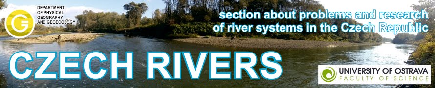
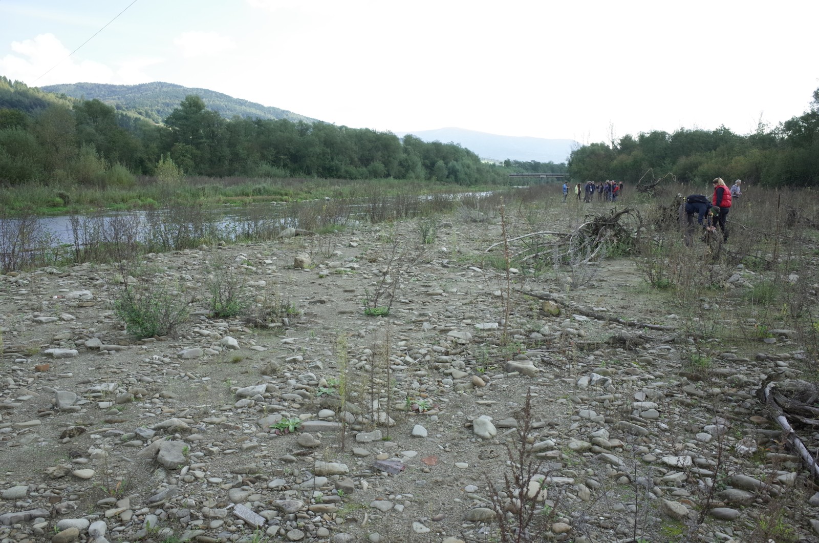
Contemporary Ostravice River channel: A – in river reach 4.5 r. km; B – in river reach 21.5 r. km; C – in river reach 27.9 r. km; D – in river reach 41.8 r. km.


ŠKARPICH, V., KAŠPÁREK, Z., GALIA, T., HRADECKÝ, J. (2016): Anthropogenic impact and morphology channel response of Beskydian gravel-bed rivers: a case study of the Ostravice River, Czechia. Geografie 121, pp. 99-120. (in Czech with English summary)